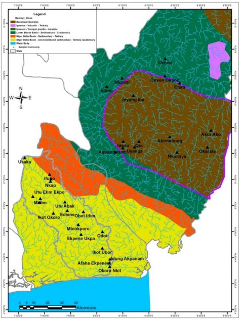
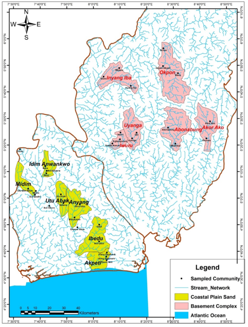
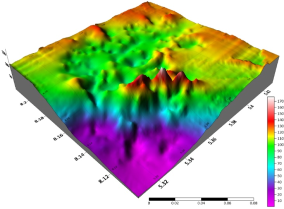
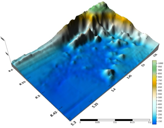
Geology plays a key role in determining the behavior of the ecosystem including its streams network and a better understanding of this concept is the first step toward ecosystem and water sustainability. Hence, this study examines geological formations and the quagmire of stream extinction in Southern Nigeria. Two different geological formations in Southern Nigeria were considered in this study which include the Coastal Plain Sands using Kwa Iboe River in Akwa Ibom State and Basement Complex in some parts of Cross River State. Six matured watersheds were purposively selected from each geological formation (six in Coastal Plain Sands and six in Basement Complex), making a total of twelve (12) watersheds. These cut across Idim Awankwo, Midim, Utu Abak, Anyang, Ibedu and Akpeti watersheds in the Coastal Plain Sands in the Kwa Iboe River and Iwuru, Uyanga, Abonabung, Akor Ako, Okpon and Inyang Iba watersheds in the Basement Complex in Cross River. The result of the summary of the morphometric characteristics shows lower bifurcation ratio in the CPS indicating watersheds in which the geologic structure does not exercise a dominant influence on the drainage pattern while the reverse is the case in BC. In area aspect, the result shows complicated values and high circularity ratio in BC due to the presence of a combination of lithological formations, leading to differential erosion and subsequently to watershed displacement. Statistical analysis using independent t-test analysis shows a p-value of 0.007 which is an indication that there is a significant difference in the morphological parameters of Basement Complex and Coastal Plain Sands as they relate to stream extinction. The summary of the study indicates that streams in the ancient basement complex rocks of Cross River State have restricted area, high values of basin relief and high bifurcation ratio due to inability of streams to erode easily, unlike the weak sedimentary rocks. More so, streams in the CPS recorded less influence from the geological structure of the basins, making the soil have loose particles and highly susceptible to infiltration and highest level of stream extinction. This supports the observable disparity on the basin resilience as one traverse along the river course. Hence, it was recommended that since the CPS is highly prone to stream extinction, desilting the stream channel should be given a priority by stakeholders.
| Published in | Engineering Science (Volume 10, Issue 3) |
| DOI | 10.11648/j.es.20251003.12 |
| Page(s) | 92-103 |
| Creative Commons |
This is an Open Access article, distributed under the terms of the Creative Commons Attribution 4.0 International License (http://creativecommons.org/licenses/by/4.0/), which permits unrestricted use, distribution and reproduction in any medium or format, provided the original work is properly cited. |
| Copyright |
Copyright © The Author(s), 2025. Published by Science Publishing Group |
Geology, Watershed, Stream Extinction, Basement Complex, Coastal Plain Sands
S/N | Parameters | Formulae |
|---|---|---|
1 | Basin Area | Area from which water drains to a common stream and boundary determined by opposite ridges (GIS Analysis). |
2 | Basin Perimeter | Outer boundary of drainage basin measured in kilometers (GIS Analysis). |
3 | Basin Length | The straight line from the mouth of the basin to the farthest point on the basin perimeter (GIS Analysis). |
4 | Form Factor | F r = A/ L2. Fr = Form factor, A = Basin area, L = Basin length |
5 | Elongation Ratio | Re= √A /π / Lb Where, A= Area of the basin (Km2) Lb=(Maximum) Basin length (Km) π =3.142 |
6 | Circulatory Ratio | Rc = 4πA/ P2 Where, A = Basin area (Km2) and P= Perimeter of the basin (Km) π=3.142 |
7 | Drainage Density | Dd = Lμ/A Where, Dd = Drainage density (Km/Km2) Lμ = Total stream length of all orders and A = Area of the basin (Km2). |
8 | Stream Frequency | Fs = Nμ/A Where, Fs = Drainage frequency (df). Nμ = Total no. of streams of all orders and A = Area of the basin (Km2). |
9 | Leminiscate Ratio | K = L2 / 4A Where L = Length of the basin and A = Area of the basin |
10 | Constant Channel Maintenance | C = 1/Dd Where Dd = Drainage Density (Is the reciprocal of drainage density) |
11 | Drainage Texture | R Nu/PR =Drainage texture, N =Number of streams, P= Drainage perimeter |
12 | Infiltration Number (drainage intensity) | If = Dd × Fs Where, Dd = Drainage density (Km/Km2) and Fs = Drainage frequency. (Also known as drainage intensity) |
S/N | Feature | Parameters | Formulae |
|---|---|---|---|
13 | Linear Features | Stream Order | Hierarchical rank (GIS Analysis) |
14 | Bifurcation Ratio | Rb = Nμ / Nμ +1 Where, Rb = Bifurcation ratio, Nμ = No. of stream segments of a given order and Nμ +1= No. of stream segments of next higher order. | |
15 | Mean Bifurcation Ratio | Rbm = Average of bifurcation ratios of all orders | |
16 | Total Stream Length | GIS Analysis (Length of all the stream km) | |
17 | Mean Stream Length | Lsm = Lμ/Nμ Where, Lμ = Total stream length of order ‘μ’ Nμ = Total no. of stream segments of order ‘μ’ | |
18 | Stream Length Ratio | RL= Lsm / Lsm-1 Where, Lsm=Mean stream length of a given order and Lsm-1= Mean stream length of next lower order | |
19 | Length of Overland Flow | Lg=1/DD Where, DD=Drainage Density (Km/Km2) | |
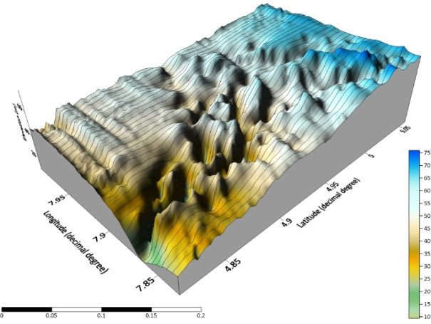
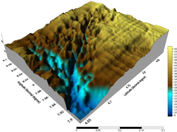
20 | Relief Feature | Basin Relief or Local Relief | H = Z – z Where, Z = Maximum elevation of the basin (m) and z = Minimum elevation of the basin (m) |
21 | Relief Ratio | Rr = H / Lb Where, H = basin relief (m) and Lb = Basin length (m) | |
22 | Basin Slope | GIS Analysis | |
23 | Ruggedness Number | R = Bh/Dd Where, Bh=Basin relief, Dd=Drainage density |
Parameter | Basement complex (BC) | Coastal Plain Sands (CPS) | ||
|---|---|---|---|---|
Mean | Range | Mean | Range | |
No. of order 1 | 32.83 | 11-53 | 16.5 | 7-34 |
No. of order 2 | 7.67 | 3-14 | 3.83 | 2-7 |
No. of order 3 | 1.83 | 1-3 | 1.5 | 1-2 |
No. of order 4 | 1 | 1-1 | 1 | - |
Total No. of Stream | 43 | 15-65 | 22.33 | 10-42 |
length of order 1 (km) | 74.86 | 21.45-135.57 | 51.00 | 23.69-104.54 |
length of order 2 (km) | 34.645 | 10.67-56.08 | 27.40 | 13.98-49.35 |
length of order 3 (km) | 18.235 | 3.8-50.32 | 14.95 | 1.84-33.14 |
length of order 4 (km) | 16.9875 | 12.22-22.05 | 15.20 | 7.4-19.75 |
Total Stream Length | 139.065 | 45.9-241.97 | 103.48 | 42.53-206.76 |
Total mean stream length | 37.41 | 7.15-80.66 | 27.34 | 14.18-51.7 |
Mean stream length 1 (lu1) | 2.33 | 1.7-3.51 | 1.75 | 0.75-2.96 |
Mean stream length 2 (lu2) | 4.745 | 2.7-6.46 | 4.96 | 1.46-12.51 |
Mean stream length 3 (lu3) | 5.00 | 1.9-6.62 | 5.95 | 3.33-8.28 |
Basin length (km) | 28.53 | 13.9845.1 | 21.47 | 16.6-28.24 |
Axial width (km) | 13.64 | 6.6-18.73 | 8.94 | 7.23-10.87 |
Bifurcation Ratio 1&2 | 4.71 | 1.57-7.43 | 4.07 | 2.67-6.8 |
Bifurcation Ratio 2&3 | 4.805 | 2.33-11 | 2.58 | 1.5-3.5 |
Bifurcation Ratio 3&4 | 2.25 | 2-3 | 2 | 2-2 |
Mean Bifurcation Ratio | 4.29 | 3.33-7.9 | 2.88 | 2.06-4.1 |
Indicator | Basement Complex | Coastal Plain Sands | ||
|---|---|---|---|---|
Mean | Range | Mean | Range | |
Area (km2) | 317.44 | 107.4-559.92 | 177.79 | 109.79-327.79 |
Perimeter (km) | 89.60 | 49.32-123.45 | 64.48 | 54.31-95.02 |
Form Factor | 0.41 | 0.28-0.55 | 0.38 | 0.28-0.52 |
Elongation Ratio | 0.36 | 0.3-0.42 | 0.23 | 0.17-0.32 |
Circulatory Ratio | 0.48 | 0.39-0.55 | 0.41 | 0.15-0.57 |
Drainage Density | 0.44 | 0.42-0.45 | 0.57 | 0.39-0.72 |
Stream Frequency | 0.14 | 0.12-0.16 | 0.27 | 0.089-0.5 |
Drainage Intensity | 0.06 | 0.05-0.07 | 0.28 | 0.18-0.39 |
Leminiscate Ratio | 0.66 | 0.45-0.91 | 0.68 | 0.48-0.9 |
Drainage Texture | 0.46 | 0.3-0.62 | 0.74 | 0.2-1.23 |
Parameter | Basement Complex | Coastal Plain Sands | ||
|---|---|---|---|---|
Indicator | Mean | Range | Mean | Range |
Highest Elevation (m) | 471.67 | 140-845 | 53.26 | 25-124.12 |
Lowest Elevation (m) | 60.00 | 5-125 | 14.77 | 7-34.76 |
Basin Relief | 411.67 | 130-805 | 38.48 | 10-89.36 |
Relative relief | 0.00 | 0.0016-0.0065 | 0.16 | 0.0013-0.31 |
Relief ratio | 0.01 | 0.0044-0.022 | 0.70 | 0.00032-1.49 |
Ruggedness Number | 0.18 | 0.054-0.346 | 0.02 | 0.0063-0.035 |
Levene's Test for Equality of Variances | t-test for Equality of Means | |||||||
|---|---|---|---|---|---|---|---|---|
F | Sig. | t | df | Sig. (2-tailed) | Mean Difference | Std. Error Difference | ||
Parameters | Equal variances assumed | 7.84 | 0.131 | 1.528 | 70 | 0.007 | 30.07924 | 19.68066 |
Equal variances not assumed | 1.528 | 41.967 | 0.134 | 30.07924 | 19.68066 | |||
NGOs | Non-governmental Organizations |
CPS | Coastal Plain Sands |
BC | Basement Complex |
Rb | Bifurcation Ratio |
DEM | Digital Elevation Model |
UTM | Universal Traverse Mercator |
WGS | World Geodetic System |
3D | Three Dimension |
| [1] | Edem, I., Uduak, C., Peter, A. and Usuah, E. (2012). Impacts of Exploitation and Gas Pipelines on Soils Along Qua Iboe River Estuary of Onna, Southeastern Nigeria. Advances in Applied Science Research 3(5): 2578-2585. |
| [2] | Enoh, C. (2000). Man-Impact on Environment. In: Inyang, I. B. (ed.) South-Eastern Nigeria: Its Environment. Kaduna: Abaam Publishing Company. |
| [3] | Eze, B. and Joel, E. (2010). Morphometric Parameters of the Calabar River Basin: Implication for Hydrologic Processes. Journal of Geography and Geology 2(1) 18-26. |
| [4] | George, U. and Akpan, E. (2020). Assessing the Impacts of Coastal Activities on the Water Quality of Qua Iboe River Estuary, South-South, Nigeria. Nature and Science; 18(5): 50-64. |
| [5] | Gupta, R. and Jindal, A. (2000). Influence of Buried Topography on Surface Drainage Pattern. International Journal of Remote Sensing, 21(2): 209-211. |
| [6] | NiMeT (Nigerian Meteorological Agency) (2023) Seasonal Rainfall Prediction (SRP) Periodic Monitoring Report. Dated – Thursday, 28 December 2023: 18-19. |
| [7] | NPC (National Population Census) (2006). 2006 Population Census Data of Akwa Ibom State, Nigeria; Abuja NPC: National Population Commission, 37 p. |
| [8] | Pareta, K. and Pareta, U. (2011). Quantitative Morphometric Analysis of a Watershed of Yamuna Basin, India using ASTER (DEM) Data and GIS. International Journal of Geomatics and Geosciences, 2(1): 248-269. |
| [9] | Saturday, U., Udosen, C., and Ubom, O. (2021) Drainage Network Characteristics of Order-3 Basins in the Sedimentary Rocks in Southeastern Nigeria: Implications on Hydrologic Processes. Conference Proceedings of the Association of Nigerian Geographers (ANG) 61st Annual Conference, held at the University of Calabar from 9th – 12th August 2021, 109 p. |
| [10] |
Tom, H. (2023) Why is the Euphrates River Drying Up and What Does It Mean? IFLScience. Retrieved from
https://www.iflscience.com January, 2024. |
| [11] | Udofia, E. P. (2010). Environmental Problems. In: Usoro, E. J. and Akpan, P. A. (eds) Akwa Ibom State: A Geographical Perspective. Enugu: Immaculate Publications Limited. |
| [12] | Udosen, C. (2009) Environmental Constraints on the Interdependence of Drainage Basin Morphometric Properties in the Upper Cross River. Global Journal of Geological Sciences 7(2) 119 – 124. |
| [13] | Udosen, C., Okon, M., Abasi-Ifreke, S. and Malachy, U. (2021) Morphometric Analysis of Lower Enyong Creek Basin in South-Eastern Nigeria; its Implications for Applied Studies. Global Journal of Pure and Applied Sciences, 27(1): 10-14. |
APA Style
Udofia, E. P., Saturday, U. U. (2025). Geological Formations and the Quagmire of Stream Extinction in Southern Nigeria. Engineering Science, 10(3), 92-103. https://doi.org/10.11648/j.es.20251003.12
ACS Style
Udofia, E. P.; Saturday, U. U. Geological Formations and the Quagmire of Stream Extinction in Southern Nigeria. Eng. Sci. 2025, 10(3), 92-103. doi: 10.11648/j.es.20251003.12
AMA Style
Udofia EP, Saturday UU. Geological Formations and the Quagmire of Stream Extinction in Southern Nigeria. Eng Sci. 2025;10(3):92-103. doi: 10.11648/j.es.20251003.12
@article{10.11648/j.es.20251003.12,
  author = {Emmanuel Peter Udofia and Unyime Udoette Saturday},
  title = {Geological Formations and the Quagmire of Stream Extinction in Southern Nigeria},
  journal = {Engineering Science},
  volume = {10},
  number = {3},
  pages = {92-103},
  doi = {10.11648/j.es.20251003.12},
  url = {https://doi.org/10.11648/j.es.20251003.12},
  eprint = {https://article.sciencepublishinggroup.com/pdf/10.11648.j.es.20251003.12},
  abstract = {Geology plays a key role in determining the behavior of the ecosystem including its streams network and a better understanding of this concept is the first step toward ecosystem and water sustainability. Hence, this study examines geological formations and the quagmire of stream extinction in Southern Nigeria. Two different geological formations in Southern Nigeria were considered in this study which include the Coastal Plain Sands using Kwa Iboe River in Akwa Ibom State and Basement Complex in some parts of Cross River State. Six matured watersheds were purposively selected from each geological formation (six in Coastal Plain Sands and six in Basement Complex), making a total of twelve (12) watersheds. These cut across Idim Awankwo, Midim, Utu Abak, Anyang, Ibedu and Akpeti watersheds in the Coastal Plain Sands in the Kwa Iboe River and Iwuru, Uyanga, Abonabung, Akor Ako, Okpon and Inyang Iba watersheds in the Basement Complex in Cross River. The result of the summary of the morphometric characteristics shows lower bifurcation ratio in the CPS indicating watersheds in which the geologic structure does not exercise a dominant influence on the drainage pattern while the reverse is the case in BC. In area aspect, the result shows complicated values and high circularity ratio in BC due to the presence of a combination of lithological formations, leading to differential erosion and subsequently to watershed displacement. Statistical analysis using independent t-test analysis shows a p-value of 0.007 which is an indication that there is a significant difference in the morphological parameters of Basement Complex and Coastal Plain Sands as they relate to stream extinction. The summary of the study indicates that streams in the ancient basement complex rocks of Cross River State have restricted area, high values of basin relief and high bifurcation ratio due to inability of streams to erode easily, unlike the weak sedimentary rocks. More so, streams in the CPS recorded less influence from the geological structure of the basins, making the soil have loose particles and highly susceptible to infiltration and highest level of stream extinction. This supports the observable disparity on the basin resilience as one traverse along the river course. Hence, it was recommended that since the CPS is highly prone to stream extinction, desilting the stream channel should be given a priority by stakeholders.},
 year = {2025}
}
TY  - JOUR
T1  - Geological Formations and the Quagmire of Stream Extinction in Southern Nigeria
AU  - Emmanuel Peter Udofia
AU  - Unyime Udoette Saturday
Y1  - 2025/12/09
PY  - 2025
N1  - https://doi.org/10.11648/j.es.20251003.12
DO  - 10.11648/j.es.20251003.12
T2  - Engineering Science
JF  - Engineering Science
JO  - Engineering Science
SP  - 92
EP  - 103
PB  - Science Publishing Group
SN  - 2578-9279
UR  - https://doi.org/10.11648/j.es.20251003.12
AB  - Geology plays a key role in determining the behavior of the ecosystem including its streams network and a better understanding of this concept is the first step toward ecosystem and water sustainability. Hence, this study examines geological formations and the quagmire of stream extinction in Southern Nigeria. Two different geological formations in Southern Nigeria were considered in this study which include the Coastal Plain Sands using Kwa Iboe River in Akwa Ibom State and Basement Complex in some parts of Cross River State. Six matured watersheds were purposively selected from each geological formation (six in Coastal Plain Sands and six in Basement Complex), making a total of twelve (12) watersheds. These cut across Idim Awankwo, Midim, Utu Abak, Anyang, Ibedu and Akpeti watersheds in the Coastal Plain Sands in the Kwa Iboe River and Iwuru, Uyanga, Abonabung, Akor Ako, Okpon and Inyang Iba watersheds in the Basement Complex in Cross River. The result of the summary of the morphometric characteristics shows lower bifurcation ratio in the CPS indicating watersheds in which the geologic structure does not exercise a dominant influence on the drainage pattern while the reverse is the case in BC. In area aspect, the result shows complicated values and high circularity ratio in BC due to the presence of a combination of lithological formations, leading to differential erosion and subsequently to watershed displacement. Statistical analysis using independent t-test analysis shows a p-value of 0.007 which is an indication that there is a significant difference in the morphological parameters of Basement Complex and Coastal Plain Sands as they relate to stream extinction. The summary of the study indicates that streams in the ancient basement complex rocks of Cross River State have restricted area, high values of basin relief and high bifurcation ratio due to inability of streams to erode easily, unlike the weak sedimentary rocks. More so, streams in the CPS recorded less influence from the geological structure of the basins, making the soil have loose particles and highly susceptible to infiltration and highest level of stream extinction. This supports the observable disparity on the basin resilience as one traverse along the river course. Hence, it was recommended that since the CPS is highly prone to stream extinction, desilting the stream channel should be given a priority by stakeholders.
VL  - 10
IS  - 3
ER  -
Department of Geography and Natural Resources Management, University of Uyo, Uyo, Nigeria
Department of Geography and Natural Resources Management, University of Uyo, Uyo, Nigeria